When caves collapse: people may be killed

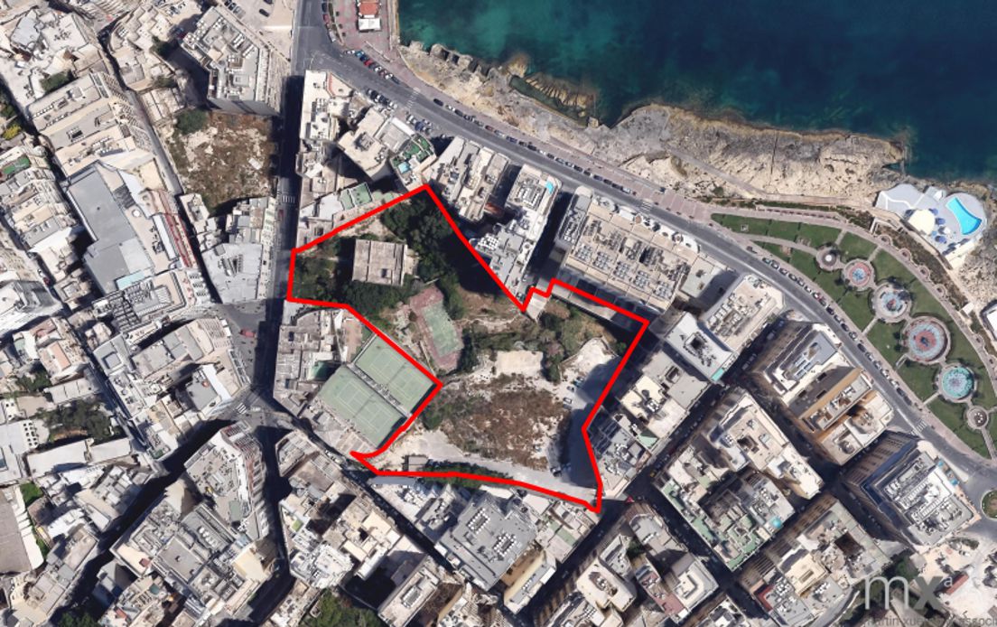
On the 14 September the Planning Authority approved application PA3487/19 which proposed the   “stabilization of dangerous rock slope; repair to deteriorated concrete wall and construction of wave dissipation slope along the Qui Si Sana coastline”.

In simple language this involves a permit for remedial works after a cave along the Sliema Qui Si Sana coastline collapsed, thereby exposing the MIDI development works immediately behind the cave: the basement level of residential blocks T14 and T17.

We have been told that the cave collapsed as a result of erosion along the coastline. Some readers may tend to forget that way back in 2016, a Maltese geologist had sounded the alarm that a “high-rise had been constructed over a fractured and eroded sea cliff, which could collapse any time soon.” The collapse in fact occurred relatively quite soon, signifying that the geologist was pointing out the obvious which was being ignored or not given due consideration by the developer and his advisors.

The point to be made is why the Planning Authority permitted the development to take place so close to the coastline. As far as I am aware, the EIA relative to the Tigne Development by MIDI does not reveal any detailed studies on the condition of the coast as well as on the impacts of erosion on the Qui Si Sana coastline and its relevance to the development of the MIDI project. The issue is not just one of remedial works but on why the Planning Authority  ignored the state of the coast, as a result permitting development too close to the coastline for comfort. The collapse is adequate proof of all this. The Planning Authority has much to explain in this specific case. Its actions, or lack of them, should be investigated.

The issue is not one relative to the structural stability of the development but of the protection of the coastline.

Erosion as a result of natural elements occurs continuously. It is a natural ongoing phenomenon.

In this respect it may be pertinent to draw attention to a report, authored by a team of geologists, dated October 2007 and entitled : “Report on Coastal Sliema. Geology, geomorphology, sites of scientific interest and coastal protection considerations.” This report was commissioned by the Sliema Local Council.

The 50-page report, which makes interesting reading, emphasises that a number of sites along the Sliema coast “are undergoing rapid coastal erosion that will increase with climate change, resulting in instability or failure in coastal infrastructure.”

Of particular interest is that the report, authored in 2007, goes on to state that “The faulted coast along Għar id-Dud is retreating rapidly by dislodgement of boulders along joints and faults. Public structures that may be affected include Tower Road promenade. The Għar id-Dud cave may also partially or totally collapse, leading to the caving-in of the overlying pedestrian promenade. If collapse is sudden and during daytime/early night time, injury and loss of lives may result.”

I have personally drawn attention of the Transport Minister to the above some time ago, however to date I am not aware that any action has been taken.

The matter was already very worrying way back in 2007 and most probably it is even worse now, after thirteen years, given that no coastal protection works have been taken in hand in the area in the intervening period.

The Għar id-Dud cave is the result of natural erosion and collapse accelerated by wave action. This is a natural process that cannot be halted unless adequate coastal protection works are initiated. If nature is left on its own, the end result is quite predictable: a complete collapse of Għar id-Dud, a caving in of the overlying pedestrian promenade and a number of dead or injured pedestrians, depending on the time of day when a collapse possibly occurs.

Will Transport Malta and the other authorities wake up from their slumber and act immediately please?

published in The Malta Independent on Sunday: 27 September 2020

Townsquare high-rise: an internal development

townsquare site


The public hearing by the Planning Authority prior to a decision regarding the issuing of the development permit for the Townsquare high-rise project was held on Thursday. The discussion was essentially channelled towards applying existing planning policy and explaining the conclusions of studies mostly carried out some eight years ago. However, as I submitted during this hearing, the proposal for the Townsquare high-rise project infringes existing planning policy.

It is known that the Floor Area Ratio Policy establishes that for a site to be considered for the development of tall buildings it needs to be surrounded by streets on four sides. In fact the expression “completely detached urban block” is used (paragraph 5.3) in the document  entitled A Planning Policy Guide on the Use and the Applicability of the Floor Area Ratio (FAR).

It is clear that, when drawing up the Development Permit Application Report, the Planning Authority case officer adopted a very wide interpretation of the term “road” without realising that the context required a strict literal interpretation.  A  member of the Planning Authority even considered it appropriate to reply to my submissions by reading out to me the definition of the term “road” as contained in section 2 of the 2016 Development Planning Act.  I was informed – in open session – by this over-enthusiastic member of the Planning Authority that the term “road” means “any road, whether public or private, and includes any street, square, court, alley, lane, bridge, footway, passage or quay, whether thoroughfare or not”.

This bright spark is probably unaware that this definition is preceded by the words “unless the context otherwise requires”. This necessarily leads to the consideration as to what is meant by a  “detached urban block” and,  in particular, whether the creation of footpaths large or small on the Townsquare site itself serves to create such “a detached urban block”.

Various doubts were expressed at the voting stage by 6 out of the 13 members of the Planning Authority present for Thursday’s sitting, leading them to vote against the approval of the development of the Townsquare project, even though the Executive Chairman considered that he had to declare in open session that the proposal (in his opinion) did not in any way infringe the Floor Area Ratio policy. Unfortunately, however, no substantial discussion took place on whether the requirement of having “a detached urban block” as the site for the proposed high-rise was being observed.

The open space around the Townsquare high-rise is a result of the 50 per cent maximum site coverage determined by the Floor Area Ratio Policy. It is an integral part of the project and consequently does not serve to detach the project from the surrounding urban blocks. In fact, this open space borders the backyards of the bordering residential properties on all sides.

The proposed development at Townsquare can be said to have an elevation on only one street, Qui- Si-Sana Seafront, due to the development of the first part of the Townsquare project some years ago. It is shielded by other third party buildings on Hughes Hallet Street, Tignè Street and Tower Road.

Access to the proposed development will be through Qui-Si-Sana Lane, Tignè Street (next to the Union Club) and a small opening between third party property onto Hughes Hallet Street in addition to the reserved point of access on Qui-Si-Sana Seafront. There is no way that this can be construed as being “a detached urban block” but rather as an internal development primarily contained by third party development.

This is just one of many reasons on the basis of which the request of a development permit for the Townsquare high-rise should have been refused by the Planning Authority. Together with various other reasons, this can be a suitable basis for contesting the decision through the submission of an appeal to overturn it.

Land use planning : beyond rhetoric

Freeport 2015


There is a common thread running through a number of local land-use planning controversies: they are tending to either ignore or give secondary importance to environmental, social and/or cultural issues, focusing instead on economic considerations.

On this page I have discussed the impact of the Freeport Terminal on  Birżebbuġa a number of times. The basic problem with the Freeport is that its impact on the Birżebbuġa community were ignored for a very long time. In fact, an attempt to include a Social Impact Assessment as an integral part of the EIA which was carried out some years ago was given the cold shoulder by MEPA. The end result was that the decision-taking process was not adequately informed of the impact of the terminal extension, both those already apparent and those which were yet to come. In particular, no assessment was made of the disintegration of the sports infrastructure in the area that has  slowly been eaten up – primarily by the Freeport.

Most of this could have been avoided through an active engagement with the local community over the years at the various stages of the project’s planning and implementation. This is why plans for the Freeport’s expansion, as indicated by the Freeport Corporation’s CEO  earlier this week in an interview with The Business Observer, should be explained  immediately. Even at this early stage it must be ascertained that the situation for  Birżebbuġa residents will not deteriorate any further.

No one in his right mind would deny that, over the years, the Freeport has made a significant contribution to Malta’s economic growth. Few, however, realise that the price paid for this economic success has been the erosion of the quality of life of the Birżebbuġa community. This is certainly unacceptable but it will only get worse, once the gas storage tanker for the Delimara Power Station is parked within Marsaxlokk Bay in the coming months, very close to the Freeport terminal.

The same story is repeating itself in other areas. Consider, for example, the 38-floor tower proposed at Townsquare and the 40-floor tower proposed for the Fort Cambridge project, both on the Tignè Peninsula in Sliema. The Townsquare assessment process is reaching its conclusion, whilst the one in respect of Fort Cambridge is still in its initial stages. Yet both are linked to the same fundamental flaw: the lack of consideration of the cumulative impact of the development of the Tignè Peninsula – which includes the MIDI development as well as the individual small scale projects in the area.

The adoption of plans and policies which have made it possible for the authorities to consider the development of the Tignè Peninsula were not subject to a Strategic Impact Assessment and, as a result, the cumulative impact of implementing these plans and policies were not identified and assessed. The end result is that the proposed towers are justifiably considered as another disruptive and unwelcome intrusion by the Tignè and Qui-Si-Sana communities.

The developers and their advisors focus exclusively on the impacts which are generated by their proposals, with the authorities generally avoiding the consideration of the big picture at the earliest possible stage.

Preliminary indications from the proposed Gozo Tunnel and the Sadeen “educational” setup at Marsaskala/Cottonera are already pointing in the same direction. In both cases, the alternatives that were generally brushed aside are the very options that need to be examined in detail in order to ensure that the challenges that will be faced in 2016 and beyond have not been prejudiced by myopic considerations in 2015.

Planning failures have serious consequences on those of our local communities that have to bear the brunt of the decisions taken for a long period of time. These can be avoided if the authorities refocus their efforts and realise that the economy is a tool which has to be a servant, and certainly not a master.

published in The Malta Independent on Sunday – 20 December 2015